
A National Spatial Data Infrastructure (NSDI) serves as a critical component of the country’s information infrastructure putting it alongside US Census Bureau TIGER files and GPS.
It provides the foundation to seamlessly share and use geographic data to address societal challenges and promote economic growth. Applications across government, industry and academia rely on geospatial information generally, and a NSDI in particular. From emergency response, market analysis to R&D. It’s a well known saying but is worth repeating “everything that happens, happens somewhere” and the better you know something about somewhere (by aggregating data from multiple sources in a NSDI) the better you can respond.
To evolve and meet demands of a rapidly changing world, our NSDI must continue to embrace innovation, strengthen partnerships, and adapt to emerging technologies so as to:
- Preserve our global geospatial leadership;
- Catalyze innovation;
- Seamlessly integrate local/state/national data sources – from underground to outer space.
This is what the 2025 Strategy document sets out.
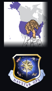
TIGER is a data file format developed by the US Census Bureau to describe physical and cultural features e.g. roads, highways, city limits, rivers, and lakes as well as census tracks. Made publicly available in 1990 it spurned growth in the private sector giving rise to Google Maps and other industry innovations using location data.
Another example is the boon in industry (in billions of dollars) that resulted from President Clinton unscrambling GPS signals in 2000.